3.30.2010

Alaska 2010 - Map Skills Test

Nasty weather abounds in the mountain ranges of Alaska. Specifically, raging winds and disorienting white-outs. So with our first major spring storm rolling in over the Pacific Ocean, we decided to test our skills with an effort to climb and ski from the summit rim of Mt. Rainier.
Map checking was not needed on Saturday as visibility was good in spite of the growing winds. At midnight, we awoke from our half-sleep and checked the weather. Winds were ridiculous at 10K which meant they would be insane at 14K and with zero visibility in the darkness and clouds, we exercised good mountain judgement by crawling back into our cozy down bags.
A few hours later as flat light filtered in, sure enough, we were at the onset of heavy snowfall in 40+mph winds! Would not have been a good time to still be going up...


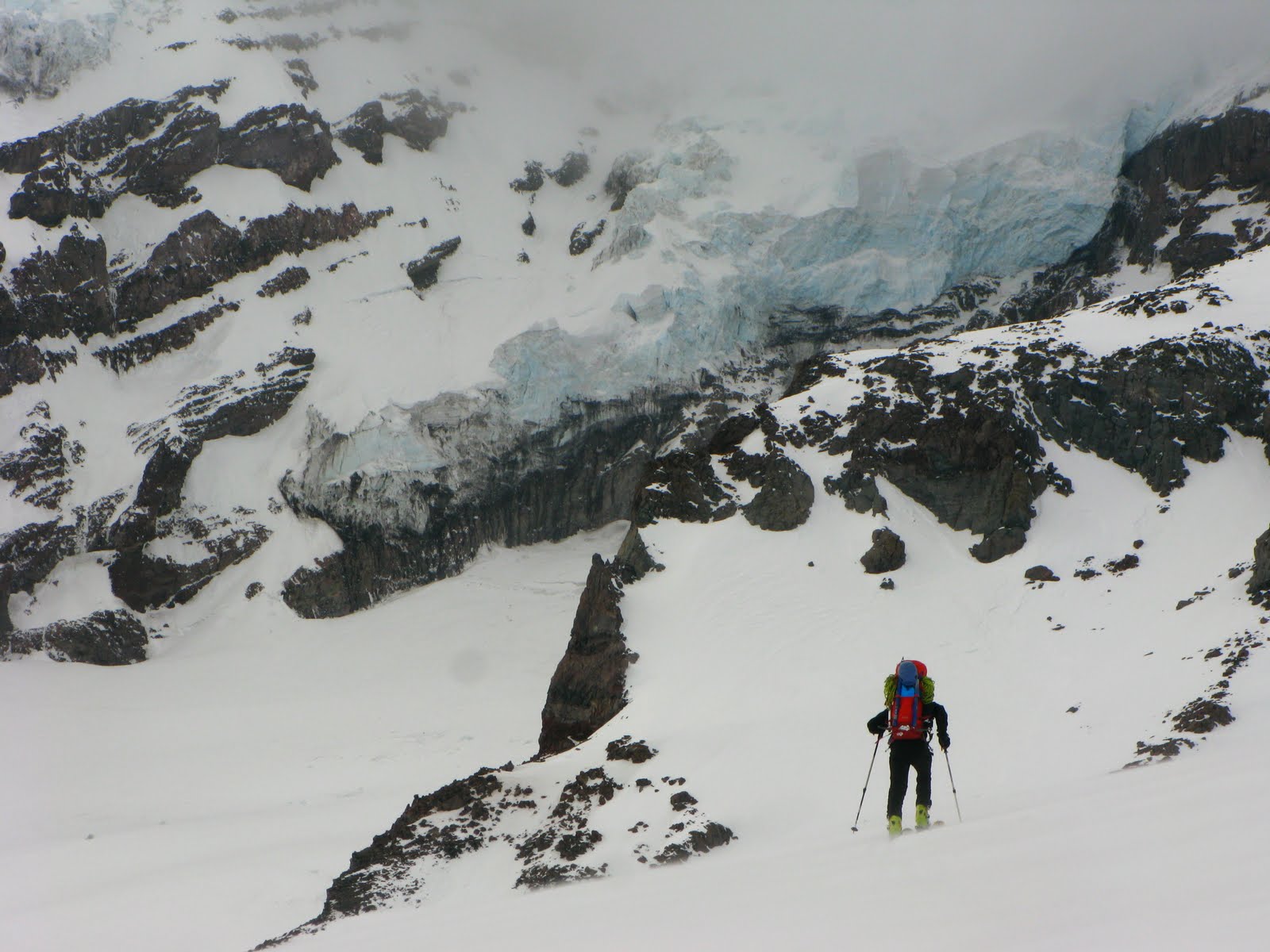
After stuffing all the miniature comforts of home and glacier gear into our packs, the first items on any trip checklist, topo map and compass, stayed out. Plotting our first bearing downward, we witnessed firsthand the intense magnetic power an active volcano like Rainier attracts as our compass needle wavered slowly back and forth.
Fun little stories like, "I came to a stop on my skis but thought I was still moving, lost my balance and fell over", flourish under these circumstances. Another like "I fell down and suddenly thought I was riding on top of a small slab avalanche" are no fun so this drove us carefully onward.
So much fun and oh how perfect the snow was, if it had only been a sunny day it would have been the best day of the season! But we were there because it won't always be sunny in Alaska.


3.22.2010

Alaska 2010 - Body Armor

Clothing is, of course, critical in an environment of radical temperature fluctuations like AK. On sunny days, the glacier and snow acts like a big mirror and can make it feel like a 90 degree day. On the other hand is below zero temps with 50mph blizzard winds that quickly forces snow and artic air thru any leak in your armor. Stay dry and you can generally stay warm. Sweat-wicking base layers that move moisture away from your skin and dry quickly are essential, as well as a solid wind/waterproof shell that can be vented when you heat up.
The standard expedition clothing system involves these two things as well as a mid layer as "active warmth" and a warm parka to throw over everything for snack breaks, setting up camp, etc.
Here is my packing list for Alaska with a question mark (
?) by the items that could be left behind at Ultima Thule Lodge if deemed unnecessary, and an exclamation mark (!) by the items that I will be wearing as we are dropped off on the glacier:

BASE LAYER
Patagonia Active Sport Boxer Briefs (3 pair)
Icebreaker Merino Wool Boxer Briefs (2 Pair) !
Smartwool Sport NTS Bottoms
Smartwool Midweight Boot-Top Bottoms
Marmot Powerstretch ¾ Bottoms !
Patagonia Capilene 2 Short-Sleeve Crew Top ?
Patagonia Merino 2 Long-Sleeve Crew Top
Outdoor Research Sequence Short Sleeve Zip-Top
Outdoor Research Sequence Long Sleeve Zip-Top !
Patagonia R1 Fleece Pullover !

SHELLS
Marmot Cortina Softshell Pants !
Marmot ROM Softshell Jacket !
Outdoor Research Foray Gore-Tex Jacket
Outdoor Research Trio Gore-Tex Pants

INSULATION
Marmot Flurry Insulated Pants ?
Marmot Baffin Vest ?
Patagonia DAS Parka

HEAD
Outdoor Research Ninjaclava
Shred Alert Beanie !
Lightweight Wool Beanie ?
Fleece Ear Band
Sun Visor

HANDS
Outdoor Research Liner Gloves
Outdoor Research Omni Fleece Gloves !
Marmot Spring Glove ?
Black Diamond Patrol Gloves
Black Diamond Mercury Mitts

FEET
Liner Socks (2 pair)
Smartwool Ski Socks (3 Pair) !

EYES
Julbo Doglan Sunglasses !
Smith I/O Goggles


Big thanks to Yukon Trading Co. of Washington State and Alpin Sales of Colorado for their Marmot clothing contributions!!!

3.09.2010

Alaska 2010 - The Goal


Plan: -Climb and then ski Mt. Bear and Mt. Bona as well as ski mountaineering on the untouched peaks in between. Bear and Bona are about 25 miles straight across from each other and we will likely attempt the larger of the two, Mt. Bona, first!!

Details:--Mt. Bear - 14,831' - 12th highest peak in Alaska
---------.----Mt. Bona
- 16, 421' - 4th highest peak in Alaska
---------.----Wrangell St. Elias NP - Largest National Park in the US

Dates: -May 1st - June 1st, 2010

2.05.2010

Alaska Sized Plans


Two years to the day after my first visit to Alaska, I will be returning to live a dream that has obsessed me for half of my 28 years – a month of exploring the remote Alaskan back country. Now before you think ‘cold’, and before you say “dangerous”, reflect on the biggest dream that you've kept alive throughout your life and fantasize of it’s fulfillment. That feeling is the substance of this trip!

Many ideas have come and gone while developing the most appealing version of the dream adventure: A climb of the tallest peak in N. America...no, too crowded. A ski traverse in the Chugach...no, who wants to hear helicopters flying around filming ski movies. A kayak trip through Prince William Sound...too much water and not enough mountain. Backpacking the Brooks Range...maybe next time!

Finally, version 2010 has taken shape through the somewhat random meeting of friends. 4 determined people have pounced on this single moment of opportunity. During a weather clearing (hopefully) in the first week of May, the baddest bush pilot in the world, Paul Claus, of Ultima Thule Outfitters will fly us in his Turbo Otter fitted with skis to the Upper Bernard Glacier dividing Mt. Bona and Mt. Bear. Wrangell-St. Elias National Park combined with Kluane National Park (Canada), makes up the largest protected mountain wilderness on earth and in 3 months, thanks to the skill set of Paul, we will find ourselves smack dab in the middle of it!

It is very difficult to find information & photos of this area as most people who visit Alaska head to one of the "less remote" national parks like Denali or Glacier Bay. There are no roads in the park and USGS maps provide the only real usable terrain info. A handful of trip reports printed in the American Alpine Journal from past mountaineers give us an idea of what challenges have been encountered while the remaining stories of this place go unpublished. This has only added to our drive to go there!


Over the coming weeks, I will detail our preparation here on this blog...

10.06.2009

That Time of Year Again

.
: :
60 miles as the crow flies east of Seattle - Jade Lake : :


8.19.2009

The Real Fountain of Youth

Round 2: After bad weather abruptly ended our trip up Mt. Olympus last year, I could hardly wait to see what I'd been missing! The 20+ mile hike in prevents one that wants to stop and eat the berries from a quick weekend return. So Ben and I set aside 4 full days, exactly one year after our initial attempt.
This particular trip for me was much more than simply another climb. Hiking from below 1,000' along a damp rain forest valley floor, then eventually higher to glacial moraine and beyond to the summit at 8,000', gives one an intimate account of the way an ecosystem supports itself and ultimately human life around it.

The Pacific NW has seen above average sun and temperatures this year and because of this, the Blue Glacier has lost all of it's annual snow leaving just the ancient, hard ice. After hearing and seeing all the happy wildlife in the forest, a step onto the glacier is literally stepping onto the source of life! Streams of pure, mineral-rich melt water meandered in all directions on the surface of the glacier. In one spot we discovered a stream gushing into a large glacier moulin that likely reached the lowest depths of the glacier!


A
taste from this water, and we had many, is what I would imagine "drinking from the fountain of youth" would taste like! I find it a bit irritating that so many people view this as "unfiltered" when in fact thousands of years of environmental evolution is the shining example of what pureness and wholeness really is!


Eating fresh mountain berries, breathing pure mountain air, and drinking straight from a glacier - I do believe that I have tasted from the Fountain of Youth!

8.11.2009

Exploring the Urban Jungle

Previously, when I thought of NYC, I thought of 'big city East Coast'. Then there are some who think of one of the largest cities in the Western World, and of course some think of "Yankees up North".
But I now understand that NYC is not about East, West, North, or South. NYC is about anything and everything, anytime and all the time!


8.03.2009

Gear That I Use: Organization

This is the first installment of a mini-series in which I will detail some of the gear I am using out there. As with most activities, it takes years to fine-tune your system and with modern manufacturing, gear options abound.
The root word of packing is 'pack' so I'll start with that:


BD Sphynx 42L Backpack - Sleek, lightweight, and it has a hydration bladder sleeve. What keeps me buying this same model when one wears out, is the homogenous fit that it provides for my back.

OR Pack Liner - If it's going to be wet, this super light liner seals everything out. Plus, you can slip it, full with all your gear, from your soggy pack in one smooth pull after reaching camp. I put my tent (or bivy sack) in the bottom of my pack and pack everything else in the liner above it.

OR Zip Sack - The smallest size holds all of my toiletry and First-Aid items as well as my compass/GPS and most other personal accessories. What makes it special is that it unzips across the top so you can see all of your items with ease.

Granite Gear Stuff Sacks - These are color coordinated, mostly waterproof, and extremely light. I put my extra clothing in one and day snacks in another. If you don't stuff them to the absolute max, you can arrange them easily inside your pack so that every bit of space is used efficiently. Just try to keep the heaviest items closest to your back.

Plastic Baggies - Ahhh, the benefits of Petroleum. These really make the final difference in a well organized pack. Unfortunately I have found that on extended trips, they become more and more difficult to seal. I am looking for a re-usable replacement...

7.20.2009

Another Jaw-Dropping Discovery

Mt. Shuksan has always had a special attraction for me. Every side of the mountain has a unique look and every time I am there, I can't help but think of the Swiss Alps. It is also adjacent to the glaciated volcano - Mt. Baker, making the location especially unique on our planet Earth.
The approach begins near Artist Point, where you drop almost a 1000' into a majestic forest valley before climbing back up again and passing the still-frozen, Lake Ann.
Our climbing route, Fisher Chimneys, is an intermediate and beautiful weaving line up the western flank of this very impressive mountain. It entails scrambling up rock and snow gullies, navigating two glaciers, and finally a rock climb on a striking ridge that seems to be above "the whole rest of the world". The downclimb though, is where the real effort is. We got out just after the sun had set on Sunday night following a weekend of pleasant sunrises, exhilarating days, and spectacular sunsets.


-Sunset from the same spot above-

It is this area where a US record snowfall fell in 1998-99. Fortunately for us, that time of year is long gone and cloudless night skies revealed to us the most dazzling display of stars either of us had seen in months! You can tell that the mountains are happy for the change of season too - the color green is on full display as if to say, "wanna come out and play "!

-200' from the summit. Photo courtesy of Jon-

7.02.2009

High and Wild

I have just returned from the most unforgettable vacation I have ever experienced - a journey on the Ptarmigan Traverse. Though many say that it looks like a lot of work, I say it is perfect effort and nothing at all like work! For 7 days, 4 good friends and I explored a remote area of North Cascades National Park that only a handful each year see in person.
It started with an early start from Seattle before a long day of gaining the bulk of our elevation. Menacing clouds scattered showers throughout the day and tried to dampen our spirits, but there was no doubt we would be grateful for persisting once they moved on.
After arriving at Kool-Aid Lake for our first camp in the rain, we awoke the next morning to more gloom. The decision was made to stay there for the night again and summit Hurry-Up Peak that day as a primer for things to come.
Day 3 - The clouds began to evaporate as we traversed westward slopes across Red Ledges and up through Spider-Formidable Col. From there we moved across eastern slopes and down to our planned camp at Yang Yang Lakes. Don't ask about the name, I have no idea...

Here we began to really feel the solitude that we craved. 2 days of technical travel would be our only option for exit now and so commitment to our goal was essential.
Day 4 - This was supposed to be a climb of Mt. Formidable and then moving camp to the next location, but the mountain had other plans. 200 feet from the summit, we encountered rapidly melting snow on top of steep rock and with zero options for setting an anchor, we decided it would be prudent for our group of 5 to turn around. Group tension had risen because of the sketchy conditions and so we decided to return to our camp at the lake for a rejuvenating swim in a lake still partially frozen. 4 days without a bath makes this especially appealing!
Day 5 - Feeling strong and charged, we started at 4am for Sentinel and Old Guard Peak. Same story on Sentinel, very close to the summit, loose and unstable snow and rock convinced us to turn our sights to Old Guard. And once on top, the view was captivating and absolutely breath-taking! Monstrous valleys that once contained massive glaciers surrounded the massif we stood at the apex of.
From there we descended westward and then crossed the head of the South Cascade Glacier before aiming for Lizard Pass. On arrival, we saw our final summit goal beckoning with awesome grandeur while below us, the most beautiful back country campsite any of us had ever visited - White Rocks Lake.

Day 6 - Just barely though, we woke up at midnight in preparation for the long day ahead. Traversing on an eastward slope around a large cirque, we witnessed the disappearance of the stars and the rising of the sun. The color of the Dana Glacier just before sunrise was so ethereal that I still have that moment sharply burned in my mind.


It was Monday morning and at the same time as the West Coast was sitting in rush hour traffic, we crested Dome Peak for our final and most spectacular summit view. There we were, above everything but the volcanic hulks (Glacier Peak & Mt. Baker), far from anyone, receiving another reward that still I find so difficult to explain. That must mean that I have found the medicine that I really need: raw elation!

Of course the effort hardly ends there and so after the summit "party", we descended into the valley below. We arrived at camp near Cub Lake ahead of schedule and with the afternoon to kill, we rigged up ropes on a large granite wall just above camp for some fun! Down it's side, a mineral rich waterfall of freshly melted alpine snow and glacier invited us to rappel along side it for another unique experience. During a gorgeous sunset and around a small campfire, we discussed our favorite experiences and talked of future trips.
Day 7 - The day that no one actually wanted to come. Sure, we were tired and a bit hungry but I can honestly say that I didn't have the usual craving for a juicy burger. I had fed myself well and developed an enjoyable mountain routine far away from the predictable structure of American society.
We still had a long ways to go, with the first 4 miles involving demoralizing travel through steep and thick undergrowth and slide alder. The forest road that gives cars access to the Downey Creek TH washed out a couple years ago slowing everybody but the most determined from using that trail. In that time the trail has become even more overgrown than it already was. After about 10 miles of purposeful hiking we finally ran out of food and water making the remaining 11 miles a "silent death march". Once to the car, celebratory yells shattered our silence. We piled into Sasha's truck, 2 in front and 3 in back before driving an hour to the original start point and our other vehicle.
Now - There's a little tear that is begging to come out of my eye in realizing the fact that this trip is over. But mostly I feel really excited to think about the bigger possibilities that this has opened up for the future!


6.18.2009

Rain-less in Seattle

Yesterday marked 29 days without rain in Seattle. Yes, I said 'without' rain - 29 full days. This has of course been a pleasant surprise, and has made for beautiful weekends in the mountains despite the rapidly melting snowpack.
For Memorial Day weekend, a jubilant Nick and I drove to Squamish, BC for three days of granite gneiss climbing on the 1,000+ ft walls that tower over this gorgeous community. There is something uniquely satisfying about topping out
on a monster wall, just in time for sunset, after climbing up it all day. This was our view (click to enlarge):

Also, two weekends ago my friend Matt and I decided to get on some rumored ice on Eldorado Peak. The unusually high temps (in the 60's) at 7,000 feet made for knee to waist deep snow sloggin' on the approach and gave us some concern over the condition of the supposed ice on our route. The NW Couloir of Eldorado Peak is a moderate grade but almost classic line on the "far side" of one of the most scenic peaks in North Cascades National Park. A 4AM start from camp gave us the time to cross the Inspiration Glacier that smothers the NW side of the peak and to a notch on it's North Ridge. There we rappelled down to another glacier below the route.


The climb went smoothly except for a rude reminder of the reality of the rising temps.
Near the top of our route we were suddenly pummeled with fist to double-fist sized chunks of ice and rock. This is when you duck into the terrain and make yourself as small as possible! This is also where you are reminded of why you lugged the helmet up 6,000 ft. Fortunately, we were left with only a few bruises and shortly afterwards, the summit crest led us to views that exclaimed definitively, the awesome-ness of our very own North Cascades!

5.04.2009

Southwest Road Trip'n

Ribbon Falls near the North Rim of the Grand Canyon


Backpacking down South Kaibab Trail, Grand Canyon


Exploring Canyonlands National Park, UT

3.13.2009

The Alps of Alpental


45 minutes from my front door there is a very popular spot that, although many know about, fewer probably realize how much it contains. Aptly named "Alp-ee" (meaning Alpental Ski Area) by local boarders and skiers, the easy access to deep powder and a variety of rock and ice climbing gives it that American flavored namesake.
My co-worker Ryan who has spent 100+ days a year snowboarding in the state's of Maine and New Hampshire for many years, recently explored this back country and said it was "by far the best terrain I have ever boarded."
Of course there are numerous wonderful places in the world to experience these activities, but 50-mile proximity to a world class city is few and far between. I am very grateful for the opportunity I have to come here!

Also unique, is the view from the summit of one of the areas highest peaks - Chair Peak. It shows you the buildings of downtown Seattle on the edge of Puget Sound, dwarfed from a distance by Olympic Mountain National Park:


12.29.2008

Embracing Change


I have always been looking for big answers. And more and more over time, ONE answer. An understanding is what I seek. An understanding of my purpose and my destiny. It's an answer that for so long I believed was always there and I just needed to figure out the right equation. But more and more I feel that this answer isn't exactly there in front of me. An answer is something that is discovered only when there is a question. So perhaps, my "answer" is the question itself. It's as mystifying as that classic wonder of what came first - the chicken or the egg.
Understanding my destiny is understanding my past and maybe the only answer to this perplexing question that I need to understand now, is that anything, any answer is possible. Life is "survival of the fittest" paired with unpredictable "chance", creating that constant and inevitable change.

Only in considering all the possibilities will I find the right questions to ask. Maybe then I will be closer to finding the answers!

Happy New Years!

10.23.2008

Four Quick Photos

Ice climbing seracs on Coleman Glacier, Mt. Baker


Cascadian Couloir, Mt. Stuart


Lake Ann near Ingalls Peak, Alpine Lakes Wilderness


Snow Lake, Alpine Lake Wilderness

9.08.2008

Knight's Reward


-My girlfriend Ruby summed it up when she said, "It's so beautiful here, I feel like I'm in a fairy tale!" It was true, the terrain defied imagination with it's lush growth and towering, ice plastered peaks. And no myth either, nearby there lay a "dragon" that resisted showing too us, it's face. We would have to climb to the top of a glaciated peak just to get a glimpse of it's tail.
The journey had begun on a cloudy Saturday morning this Labor Day weekend. Four of us, all with a deep thirst for adventure and awe-inspiration, meandered steadily up Hannegan Pass Trail until Ruth Mountain came into view.
Ruth Glacier is a true moderate and perfect for introducing friends to the exciting activity of mountaineering. For such an amazing area, it is surprising more people don't venture to this far away corner of the North Cascades. But then thankfully, the masses have never been the type to seek out unique and remote areas. Only the few, represented as one courageous soul, that knight in shining armor, ever come face to face with the mystery, and only he can claim the beautiful reward that awaits if he perseveres.

-This fairy tale continues with each of us pushing our tiring bodies up Ruth Glacier, still fantasizing of the long-rumored reward that awaited our arrival. Some effort later, our tents went up just 15 feet below the summit while North-Westerly winds tossed clouds and snow at us, as if breath from the dragon. It was giving us the expected fight, and it was up to us to utilize our modern armor to survive the blast.
Early the next morning, while we nourished ourselves with back country style beans and rice, the ancient monster began to show it's rugged face. Clouds scattered to reveal our uncanny camp right on the tip of it's tail. A rightward arcing curve of a narrow and jagged ridge led slowly around a cirque to the bulky body of Mt. Shuksan. A massif of a mountain inspiring all of those brave and persistent adventurers who willingly fight the battles of the human mind and body that prevent so many from even an attempt.
The effort of the battle made the reward even more beautiful than the knight had ever imagined! Now the next battle begins: How would he ever convince people the truth of the glories of his adventure and the worthiness of the battle.